


 Expands Exclusive Partnership With PhonePe")


 Expands Vehicle Service")


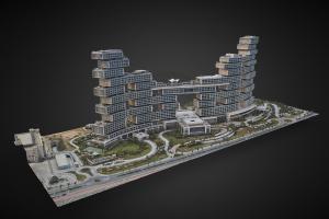
3D Model of Atlantis
Reliable Mapping and 3D Modeling with 6 Axis Gyro Stabilization and Phase One 100 Megapixel Metric Camera
DUBAI, UNITED ARAB EMIRATES, March 13, 2023 /EINPresswire.com/ — Our 3D mapping system is the cutting-edge solution to acquiring high-quality aerial images for mapping, Photogrammetry and 3D modeling. The system is built with a 6-axis gyro stabilization mechanism to provide stable and crisp images, making it the perfect choice for professionals who require accurate and reliable data for their projects. The system comes equipped with a built-in Phase One Metric camera, known for its advanced capabilities and excellent image quality.
One of the key features of our 3D mapping system is its ability to acquire data from locations close to airports and urban areas where drones may not be permitted to fly. This makes it an ideal solution for projects that require data acquisition in such restricted areas. Our system is designed to be mounted on a helicopter or airplane, allowing it to acquire images from a safe and legal altitude, all while delivering the high-quality images needed for accurate mapping and 3D modeling.
The use of our 3D mapping system can be applied in a variety of industries, including construction, urban planning, environmental monitoring, and disaster management. It can also be used to map out large areas, such as national parks or agricultural lands, to get a better understanding of the terrain and landscape.
Our 3D mapping system is operated by experienced professionals who understand the importance of accuracy and efficiency in data acquisition. The system is controlled by a skilled pilot, who uses specialized software to plan and execute the flight path, ensuring that the images captured are of the highest quality and meet the project requirements. Our team of experts can also provide post-processing services, including photogrammetry and 3D modeling, to deliver accurate and detailed data that can be used for a variety of applications.
In conclusion, our 3D mapping system is a game-changer in the field of aerial image acquisition. Its advanced capabilities, coupled with its ability to acquire data from restricted areas, make it the ideal choice for professionals who require accurate and reliable data for their projects. Our team of experts is ready to work with you to deliver the data you need, with the highest level of accuracy and efficiency. Contact us today to learn more about our 3D mapping system and how it can benefit your projects.
Hatim Saleh
CHOPPERSHOOT
email us here
Visit us on social media:
LinkedIn
Instagram
![]()
